Question bank

Chapter-1   Representation of Geographical Features
Q-1 Answer the following questions.
(a) State three common methods of representing relief features on a map.
(b) What do the following colours generally indicate on a relief map? (i) Blue (ii) Black (iii) Green (iv) Yellow (v) Brown (vi) Red (vii) White patches
Q-2 Answer the following questions.
(a) Define a contour.
(b) How are the following relief features represented by a contour map? (i) Steep slope (ii) Gentle slope (iii) Flat land
(c) Given below is an elevation map. Use the information given to draw its contour map.
Q-3 Answer the following questions.
(a) Define a scale.
(b) Name the three common types of scales used for representing distances.
(c) Represent the scale 1 cm = 1000 km in the three scales mentioned in 3b.
Q-4 Study the illustration shown below and do as instructed.
(i) Measure the distance of one division on the index card and write its value in cm.
(ii) What distance does one division on the index card correspond with on the ground? Hence, what is the scale used?
(iii) What is the distance (in metres) between house A and house B?
Q-5 State whether the following statements are true or false .
(i) In a Representative fraction scale, units are not mentioned.
(ii) A border is a line that divides one nation or part of a country from another.
(iii) A topographical map is a small scale map.
(iv) Contour lines show the steepness of slope of the land.
(v) The vertical lines on a topo sheet are called Northings.
(vi) A divider can be used to measure distances along a curve.
(vii) A ratio scale is also known as International Scale or Natural Scale.
(viii) Elevation is the height of the Earth 's surface above or below sea level.
(ix) Snow capped peaks are shown in white on a map.
(x) 1 km is equal to 10000 cm.
Q-6 In map [Al 1 cm = 1000 km while in map [Bl, 1 cm = 1 km . Which of the two maps - A or Bis:
(i) A small scale map
(ii) A large scale map
Chapter-2   The Atmosphere
Q-1 Answer the following questions.
(a) What is the atmosphere?
(b) List three important effects of the atmosphere.
(c) Arrange the following compounds of air in order of their increasing composition (by volume) and state the two functions of each. Carbon dioxide, Oxygen, Nitrogen
(d) Air contains traces of chemically inactive gases also. Name any two such gases and state one function of each.
(e) State the importance of water vapour in the atmosphere.
(f) Global warming can lead to glaciers melting and coastal flooding. What is the consequence of this?
(g) Explain the effect of ozone depletion on: (i) Human health (ii) Plants (iii) Aquatic ecosystems
Q-2 Name the five layers of the atmosphere in order of increasing height and identify each from the characteristics given below.
(i) Free from clouds, hence provides ideal flying conditions for large jet planes.
(ii) Temperature rises dramatically, reaching upto 1480°C.
(iii) The temperature in this layer ranges from 300°C to 1650°C.
(iv) This is the second layer of the atmosphere.
(v) All weather changes occur in this layer.
(vi) Ozone is present in this layer.
(vii) In this layer, the gas molecules break up into ions.
(viii) This layer merges with interplanetary space.
(ix) This layer extends to a height of 80 km.
(x) This layer absorbs X-rays and the ultraviolet radiations of the Sun.
Q-3 Fill in the blanks:
(i) The layers of the atmosphere have been defined on the basis of changes in ________ with increase in height.
(ii) The _________ gas absorbs some of the ultraviolet radiation of the Sun.
(iii) Methane, chlorofluorocarbons, nitrous oxide and carbon dioxide are known as _______ gases.
(iv) Excessive warming up of the Earth due to carbon dioxide accumulating near the earth's surface is called ________________ , ________________
(v) The ________________ was discovered over Antarctica.
Chapter-3   Weather and Climate
Q-1 Answer the following questions.
(1) State three differnces between weather and climate.
(2) Name the six main components of weather.
Q-2 State whether the following statements are true or false . Correct the incorrect statements.
(i) During the rainy season, clothes take longer to dry.
(ii) When the temperature increases, the rate of evaporation decreases.
(iii) The amount of water vapour varies from time to time and place to place.
(iv) Condensation can only occur when the air becomes saturated with water vapour.
(v) 76 cm of mercury is equal to 1000 mb.
(vi) Winds always blow from an area of low pressure to an area of high pressure.
(vii) A wind is named according to direction in which it blows.
(viii) Winds are deflected to the left in the Northern Hemisphere.
(ix) A wind vane is used to measure wind speed.
(x) When the temperature decreases, the relative humidity decreases.
(xi) Condensation can only occur when the air becomes saturated.
(xii) An onshore wind contains less moisture than an offshore wind.
(xiii) Absolute humidity is always expressed as a percentage.
(xiv) Evaporation occurs only at high temperatures.
(xv) Evaporation causes cooling.
Q-3 Give the technical term for each of the following:
(i) The amount of water vapour in the air.
(ii) The process by which water in the form of water vapour is lost from the aerial parts of the plant.
(iii) Small particles of dust or smoke in the atmosphere around which water vapour condenses.
(iv) A combination of fog and smoke in the atmosphere.
(v) Air in motion.
(vi) A line drawn on a map joining all places with equal atmospheric pressure reduced to sea level.
(vii) A line drawn on a map joining all places with equal average rainfall.
(viii) A line drawn on a map joining all places with equal average temperature.
(ix) The process by which vapour changes into the solid state without going through the liquid stage.
(x) The process by which a solid changes into the gaseous state without going through the liquid stage.
Q-4 Identify the family of cloud from the clues given:
(i) Fluffy heaps of clouds
(ii) Wispy and feathery clouds.
(iii) Clouds like fish scales.
(iv) Thunderclouds
Q-5 Fill in the blanks:
(i) _________ is the primary source of water on Earth.
(ii) Standard sea level pressure is ________ cm of mercury column.
(iii) Warm air can hold ________ (more/less) water vapour.
(iv) Wind ________ (increases/decreases) the rate of evaporation.
(v) When the air is holding the maximum amount of water it can hold, the air is said to be ___________
(vi) Precipitation is classified according to its ________ when it reaches the ground.
(vii) The ________ scale is used to show the strength of the wind.
(viii) When the ________ difference between areas increases, the strength of the wind also increases.
(ix) Clouds are classified on the basis of their ________ and the ________ at which they are formed.
(x) ________ is formed when small particles of dust or smoke in the atmosphere around which water vapour condenses.
(xi) A combination of fog and smoke in the atmosphere is called ______________
(xii) ________ clouds are wispy and feathery.
Q-6 Name:
(i) The instrument used to measure relative humidity.
(ii) Five different forms of condensation.
(iii) The most common form of precipitation.
(iv) The three different states of water.
(v) The instrument used to measure atmospheric pressure.
Q-7 Give Reasons:
(i) Mornings are cooler than afternoons.
(ii) Summers are hotter than winters.
(iii) Nights are always cooler than days throughout the year.
(iv) Temperature decreases as we move away from the Equator.
(v) Hills and mountains are cooler than places in the plains.
(vi) A high relative humidity makes us uncomfortable.
(vii) In a Wet and Dry Bulb thermometer, one of the thermometer has a piece of cloth around the bulb.
(viii) Difference in air pressure causes winds.
Q-8 Distinguish between:
(i) Absolute humidity and Relative humidity
(ii) Evaporation and Condensation
(iii) Condensation and Precipitation
Q-9 On warm summer days, the land heats up more quickly than the ocean.
(i) In which direction will the wind blow as a result?
(ii) Why are there often no winds in the morning?
Chapter-4   Weathering and Soil Formation
Q-1 Answer the following questions.
(a) Complete labeling the figure below which shows the formation of sedimentary rocks.
(b) Write a short explanation of the diagram.
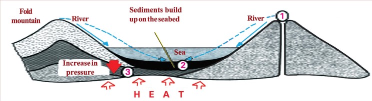
Q-2 Match up the three rock types to the numbers 1, 2 and 3 on the diagram.
Q-3 Name:
(i) The internal processes that bring about changes on the Earth's surface.
(ii) The external processes that bring about changes on the Earth's surface.
Q-4 Distinguish between:
(i) Rock and Minerals
(ii) Igneous rocks and Sedimentary rocks
(iii) Weathering and gradation
(iv) Mechanical weathering and chemical weathering
Q-5 Give geographical reasons:
(i) The density of rocks increases with depth.
(ii) Igneous rocks are called primary rocks.
(iii) Plutonic rocks have larger crystals than volcanic rocks.
(iv) Sedimentary rocks are also called stratified rocks.
(v) Overgrazing of land by animals results in soil erosion.
Q-6 Fill in the blanks:
(i) The common minerals found in rocks are _________ and ____________
(ii) The term "igneous" comes from the Latin word ignis which means ____________
(iii) _________ is the removal of trees and other vegetation which hold the soil together.
(iv) Gems are found in _________ rocks.
(v) The removal of soil by running water and wind is known as _______________
(vi) The effort by humans to prevent or reduce soil erosion is called _______________
(vii) ___________ is the planting of trees and other vegetation on hill slopes and uncultivated land.
(viii) The effect of ___________ is to produce a layer of loose material on the surface of the Earth.
(ix) During ___________ weathering, the materials that make up the rocks are changed.
(x) ______________________ is a physical process in which the rock is broken into smaller pieces, each retaining the characteristic of the original rock.
(xi) ___________ is the slow squeezing of sediments to form hard rock.
(xii) As a result of metamorphosis, granite may get changed to _________ , limestone to ___________ , shale to ________ , basalt to ___________ and ___________ to quartzite.
Q-7 Explain briefly how the following contribute to the weathering process:
(i) Large difference in temperature
(ii) Water as an agent of chemical weathering
(iii) Frost
(iv) Plants and trees
(v) Burrowing animals
Q-8 Take two tin lids and paint one white and the other black. Place both of them in the sun for five to ten minutes.
(i) What is the difference in temperature when you touch them?
(ii) How would this affect a rock if it had a mixture of colours?
(iii) In what areas of the world do you think this type of weathering would be most effective.
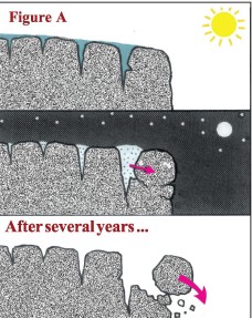
Q-9 Look at Figure A and explain how frost and temperature changes might alter this rock.
Q-10 Explain the following terms:
(i) Soil creep
(ii) Landslide
(iii) Mudflow
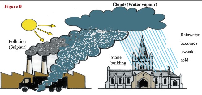
Q-11 If you look at a lot of old buildings and monuments, you can see the walls and statues are beginning to crumble. They are being eaten by a weak acid. Look at figure Band explain why.
Q-12 Answer the following
(a) What is soil?
(b) State the significance of the following, present in the soil : a. Mineral particles b. Humus c. Moisture d Air

(c) State the significance of the following, present in the soil : a. Mineral particles b. Humus c. Moisture d Air

Q-13 Explain briefly how the following factors help in soil formation:
(i) Moisture in the soil
(ii) Vegetation
(iii) Bacteria and fungi present in the soil
Q-14 Explain why:
(i) Hills and slopes usually have a thin soil layer.
(ii) Plains and valleys usually have a thick soil layer.
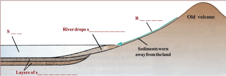
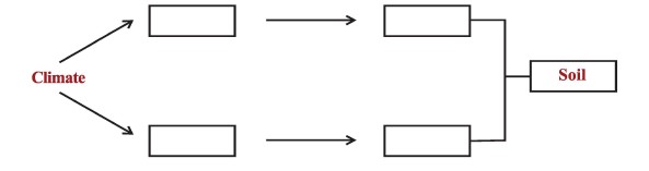
Q-15 Complete the following diagram to show the process that lead to soil formation.
Q-16 In which stage of soil formation does the following happen?
(i) Humus layer is formed.
(ii) Mineral is distributed in the soil.
(iii) Surface rock begins to break.
Q-17 Answer the following questions.
(a) Which component of the soil makes the soil fertile?
(b) Name the soil component that is responsible for the mineral content of the soil.
(c) What is a soil profile? Name the four distinct layers seen in a typical soil profile.
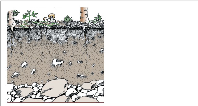
Q-18 In the diagram given below, name and mark the following:
(i) Layer which provides the mineral content of the soil.
(ii) The layer rich in humus.
(iii) The layer which consists of sand and clay.
Q-19 Answer the following questions.
(1) What is soil erosion?
(2) Explain why wind and water are regarded as powerful agents of erosion.
Q-20 Answer the following questions.
(1) What is soil conservation?
(2) State three ways in which afforestation helps in soil conservation.
(3) Name three farming techniques that are effective in controlling soil erosrion.
Q-21 State whether the following statements are true or false:
(i) Oxygen circulating in the soil is required for the respiration of soil organisms.
(ii) All types of rocks are formed directly or indirectly from metamorphic rocks.
(iii) Sedimentary rocks are formed by the erosion, transportation, deposition and consolidation of sediments.
(iv) Rocks break up when they are exposed to weather phenomena like changes in temperature, humidity and precipitation.
(v) Weathering is a dynamic process while gradation is a static process.
(vi) Acid rain can dissolve limestone and other rocks that have calcium carbonate.
(vii) A mudflow is a sudden collapse of a large mass of hillside, usually after heavy rains.
(viii) Plants absorb nutrients directly from the atmosphere.
(ix) Soil erosion takes place when soil is removed faster than it is formed.
(x) Contour ploughing is ploughing along the outline of the field in a circular manner.
Chapter-5   Industries
Q-1 Answer the following
(a) State the factors that are necessary for setting up an industry.
(b) What are the activities included in the Automobile Industry? State the basic requirements for this industry.
(c) What is shipbuilding? State the basic requirements for this industry.
(d) What are the activities included in the Fishing Industry? State the difference between inland fishing and marine fishing.
(e) What is a hinterland?
Q-2 Pick the odd one out and give a reason for your selection.
(i) Cotton textile Industry , Sugar Industry , Vegetable oil industry , Paper Industry
(ii) Iron and Steel Industry , Furniture Industry , Shipbuilding Industry , Automobile Industry
(iii) Silk Textile Industry , Leather Industry , Handicraft Industry , Dairy Industry
(iv) Mumbai , Pune , Visakhapatnam , Vadodara
(v) Gurugram , Damodar Valley , Meerat , Varanasi
Q-3 Give two examples of each:
(i) Large scale Industry
(ii) Medium scale Industry
(iii) Village Industry
(iv) Cottage Industry
Q-4 Explain why:
(i) Sugar mills are located close to the sugarcane fields.
(ii) The iron and steel industry is located close to regions where iron ore, manganese, coal and limestone are found.
(iii) Heavy industries are generally set up near railway stations or navigable rivers.
(iv) The Ruhr region is one of the largest industrial regions in Europe.
(v) In India, the steel industry is concentrated in eastern India.
(vi) India ranks second in the world production of sugar although it is the largest producer of sugarcane.
(vii) The Information Technology (IT) Industry is one of the strongest industries in the world.
(viii) The sugar industry in south India have seen a rapid growth in recent years.
Q-5 Name:
(i) The two chief centres for iron and steel production in Jharkhand.
(ii) Two States in India where the cotton textile industry has developed significantly.
(iii) Three types of refined sugar obtained from raw sugar.
(iv) The three cities that comprise the Silicon Triangle of India.
(v) A major IT hub in USA. Also state the factors influencing the location of IT industries.
(vi) Three commercially important by-products obtained during processing of sugar. Also state the use of each.
(vii) The leading producer of sugar in the world.
(viii) The three types of mill associated with the cotton textile industry and state the role of each.
(ix) The world's largest shipbuilding nation.
(x) Three shipbuilding centres in India.
(xi) The States that constitute the "sugar belt" of India.
Chapter-6   Energy and Power Resources
Q-1 Explain the following terms:
(i) Renewable source of energy.
(ii) Nonrenewable source of energy.
Q-2 From the list given below, circle those that are renewable sources of energy.
Coal , Solar energy , Hydroelectric power , Firewood , Wind energy , Natural gas , Petroleum , Tidal Energy
Q-3 Fill in the Blanks:
(i) About 25% of the world's coal reserves lie in ____________ .
(ii) Destructive distillation of coal produces _______ , _______ , ______ _ and ________ .
(iii) _______ and _______ have the largest oilfields in the world.
(iv) Coal is formed from dead plants by ____________ .
(v) In India, coal is mined in _______ , _______ , _______ and ___________ .
(vi) Solar energy can directly be available in the form of organic chemical energy through green plants during _____________ .
(vii) In India, geothermal plants are located at _________ in Ladakh and _________ in Himachal Pradesh.
(viii) In India, tidal mill farms have been set up along the _______________ in Gujarat.
(ix) The _________ has the greatest number of nuclear power plants.
(x) The hot water close to the Earth's surface that comes to the surface is called ___________ .
Q-4 Answer the following questions.
(a) Petroleum is refined to give many useful products. Name three such products and state any one use of each.
(b) The water used for generating hydroelectricity is not consumed or contaminated in any way and is still available and suitable for use. State some of the ways this water can be used.
Q-5 State whether the following statement are true or false. Correct the incorrect statement.
(i) In India, petroleum is found in Assam, Bombay High, and the deltas of the Krishna and Godavari rivers.
(ii) When Natural gas burns, it causes a lot of pollution.
(iii) About one fourth of the natural gas reserves in the world are found in Germany.
(iv) Russia is the leading producer of hydroelectricity in the world.
(v) The Bhakra-Nangal multipurpose project is located on river Beas.
(vi) The alternate energy, that can replace or reduce dependence on the conventional sources of energy are termed as conventional energy.
(vii) Natural gas is found along with crude oil or petroleum.
(viii) Natural gas consists of mainly methyl alcohol.
(ix) India has more than fifty hydropower projects.
(x) Fuel wood is generally consumed for domestic purposes mainly in urban areas.
Q-6 Identify the type of energy from the description given:
(i) Energy is obtained by harnessing the energy stored in the nucleus of atoms of naturally occurring radioactive elements like uranium, thorium and plutonium.
(ii) Energy derived from the use of the heat in the Earth's interior.
(iii) Energy obtained from organic waste.
(iv) Energy transmitted from the Sun in the form of electromagnetic radiation.
(v) Energy produced by the rotation of windmill.
(vi) Energy harnessed from the alternate rise and fall of the ocean waters.
Q-7 Name:
(i) Three multipurpose projects located in north India.
(ii) Three multipurpose projects located in south India.
(iii) The river on which the Sardar Sarovar dam is built.
(iv) The location of any three nuclear power plants in India.
(v) Three states in India which have wind farms.
Q-8 State three advantages of each:
(i) Renewable energy source like wind, water and sun.
(ii) Use of biogas as energy source.
(iii) Multipurpose project
Chapter-7   Europe
Q-1 Name or state:
(i) The latitudes and longitudes within which Europe lies.
(ii) The three physical divisions of Europe.
(iii) The countries known as the low countries.
(iv) The political divisions that make up Great Britain.
(v) The countries referred to as the Balkan States.
(vi) The countries that make up the Iberian Peninsula.
(vii) The largest European country.
(viii) The smallest European country.
(ix) The collective name applied to Norway, Sweden and Denmark.
(x) The countries known as the Nordic countries.
(xi) The European republics formed when USSR broke down in 1991.
(xii) The two independent countries that emerged when Czechoslovakia ceased to exist in 1993.
(xiii) The countries that form the British Isles.
(xiv) The region known as Lapland.
(xv) The countries formed when Yugoslavia broke up in 1991.
(xvi) Two seas located to the: a. East of Europe b. West of Europe c. South of Europe
(xvii) Two islands located in the Mediterranean sea.
(xviii) Two salt water lakes in Europe.
(xix) The water body that separates Europe from Africa in the West.
(xx) The water body that separates the British Isles from the mainland.
(xxi) The mountains in the east that separate Europe from Asia.
(xxii) The characteristic coastline of Norway.
(xxiii) The longest river of Europe.
(xxiv) A city located on the Danube.
(xxv) A peak in Switzerland close to the Italian border.
Q-2 Explain briefly:
(i) Europe can be considered a peninsula.
(ii) Europe has excellent harbours.
(iii) The Great European Plain is suited for agriculture.
(iv) Inland waterways have developed in the plains of Europe.
(v) Finland is not a part of the Scandinavian countries.
Q-3 From the clues provided, identify the rivers of Europe.
(i) It rises in the Valdai Hill and empties into the Caspian Sea.
(ii) It is the longest river in France.
(iii) It is the only east flowing river of Europe.
(iv) It is the third longest river of Europe.
(v) It forms a large delta on the coast of the Sea of Azov.
(vi) Paris is situated on its banks and Le Havre is a leading sea port on its estuary.
(vii) It empties into the Mediterranean Sea and Marseilles is an important port at its mouth.
(viii) It is a river of Germany, which flows into the Baltic Sea.
(ix) It is the busiest river of Europe; Rotterdam is situated at its mouth.
(x) It forms the fertile Lombardy Plain before emptying into the Adriatic Sea.
Q-4 Answer the following questions.
(a) Distinguish between the mountains that make up the Central Plateau and the Alpine System.
(b) Name the three physical divisions of Europe.
Q-5 Fill in the blanks:

(i) The Central Plateau includes the Plateau of _________ , the Plateau of _______ the of Germany, the Central _________ and the _________ of France.

(ii) ________ is the highest peak in the Alps.
(iii) The Alpine branch, which forms a border between Spain and France is known as the ____________ .
(iv) The Alpine branch running through Italy is called the ____________ .
(v) The Eastern end of the Alps, along the Adriatic Coast is known as the _____________ , _____________
(vi) The Caucasus Mountains lie between the _________ sea and the _________ sea.
(vii) _________ , the highest peak of Europe lies in the Caucasus.
(viii) The mountains of Northern Spain are called the _____________ .

(ix) A branch from the eastern end of the Alps curve down to the Black Sea forming the _______ mountains, the _________ Alps and the _________ Mountains.

(x) The Alpine System is a part of the Mid-World Mountain belt which stretches from the _______ in Spain to the _________ , ________ in Central Asia.

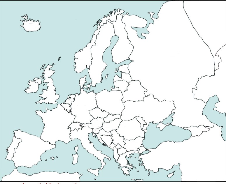
Q-6 On the map of Europe given below:
(a) Write the names of each country in the correct place. If a country is very small, draw a line from the country to an open space on the page and write its name there.
(b) Use different colours to show each of the following groups of countries : (i) The Scandinavian countries (ii) France (include the island) (iii) The Benelux countries (iv) Italy (include the islands) (v) The Balkan countries (vi) Countries of former Soviet Union (vii) Countries of the Iberian Peninsula (viii) Countries of former Yugoslavia (ix) United Kingdom (x) Countries of former Czechoslovakia
Q-7 Answer the following questions.
(i) Is Norway north or south of Italy?
(ii) Name the countries that form a border with Poland.
(iii) Through which countries does the Arctic Circle pass?
(iv) Through which country does the River Volga flow?
(v) Name an island country that lies in the North Atlantic Ocean.
(vi) Name at least 7 landlocked countries of Europe.
(vii) Name at least 4 large islands in the Mediterranean Sea.
(viii) Name the European countries that have a coast along the Black Sea.
Q-8 Name the physical division to which the following regions or landforms belong:
(i) Valdai Hills __________________________
(ii) Apennines ________________________
(iii) Andalusia ___________________________
(iv) Northern parts of Ireland ________________________
(v) Black Forest ______________________
(vi) Scandinavian Highlands ____________________
(vii) Canterbrian Mountains ___________________
(viii) Central Massif ____________________
(ix) Lombardy Plains _____________________
(x) Balkan Mountains ______________________
Q-9 State whether the following statements are true or false.
(i) The Central Plateau is a chain of young fold mountains.
(ii) The Alpine system is a remnant of old mountains of the Hercynian period.
(iii) The Ural mountains (in Russia) are a part of the Central Plateau.
(iv) The Plateau of Bohemia lies in the Czech Republic.
(v) The Matterhorn is the highest peak in the Alps.
(vi) Mt. Blanc is the highest peak of Europe.
(vii) The Caucasus Mountains lie between the Black Sea and the Caspian Sea.
(viii) Mt. Elbrus is located in the Alps.
(ix) The mountains of the Central Plateau do not exceed 1600 m in height.
(x) Mt. Blanc is about half the height of Mt. Everest.

(ix) The mountains of the Central Plateau do not exceed 1600 m in height.

Q-10 Answer the following questions.
(1) Explain the effect of the following factors on the climate of Europe: (i) The North Atlantic Drift (ii) The Westerlies
(2) State the main characteristics of the climate of Europe and name the five climatic regions of Europe.
(3) State and explain the type of climate experienced by the following countries or regions. a. Romania b. Greece c. Hungary d. Norway e. Northern most part of Finland. (ii) What is the characteristic vegetation of the regions named in (i).
Q-11 State whether the following statements are true or false:
(i) Deciduous trees of the Temperate Zone shed their leaves in winter.
(ii) Cyclones of temperate latitudes are called depressions.
(iii) The Westerlies are offshore winds in Western Europe.
(iv) Croatia receives winter rain.
(v) Citrus fruits are cultivated in the Mediterranean region.
Q-12 Switzerland is a land of pristine alpine peaks, rivers, streams, waterfalls and more than 1500 lakes
(i) Name three peaks which attract a large number of tourists.
(ii) Name three picturesque lakes of Switzerland.
(iii) Name the three principal rivers that flow through Switzerland.
(iv) Name the mountain peak known as the "Roof top of Europe".
(v) Europe's largest waterfall is located in Switzerland. Name the waterfall and the town near which it is located.
Q-13 Answer the following questions.
(1) What are the type of activities one can enjoy in Saint-Moritz and which makes it one of the world's most famous and popular holiday resorts?
(2) Name two well known tourist attractions in Bern which date back to medieval times. State the features that draw tourists to these landmarks.
(3) What are the type of accommodations available to tourists in Switzerland?
(4) Explain why the main occupation of the Swiss people is now in the business and the service industry.
Q-14 Fill in the Blanks:
(i) ___________ is the capital of winter Olympiads.
(ii) The prominent language of Switzerland is ___________.
(iii) The official languages of Switzerland include ___________ , ____________ , ______________and ___________
(iv) The Swiss National Day is celebrated on ___________
(v) ____________ is the traditional occupation of the Swiss people.
(vi) ____________ is the traditional occupation of the Swiss people.
(vii) Among dairy products, Switzerland is famous for its huge variety of ____________ and ___________
(viii) The manufacturing sector of Switzerland is known for making ____________ instruments like watches.
(ix) ____________ trains, ____________ and ____________ are means of transport used for reaching the alpine peaks.
(x) A large variety of wildlife is found in the ____________________
Chapter-8   Africa
Q-1 Fill in the blanks:
(i) Africa comes very close to Asia at the Strait of ____________ .
(ii) Mt. Kilimanjaro is an _________ volcano.
(iii) Victoria Falls is found on the River _____________ .
(iv) The _________ Mountains are a range of fold mountains, in the northeast of Africa.
(v) The Great Rift Valley extends from _________ in the south to _________ in the north.
(vi) Most of Africa is a _________ made up of old hard rock.
(vii) The Atlas Range is an example of a ___________ mountain.
(viii) The _________ mountains are not true mountains.
(ix) The Zambezi river is the longest river in Africa.
(x) Lake ________ lies at the Equator.
(xi) The Congo river is known as _________ at its head,and elsewhere as the ___________ .
(xii) The ______________ _______________ Valley is one of the most unusual landforms in Africa.
(xiii) Cracks which appear on the Earth's surface are known as ____________ .
(xiv) The River Niger empties into the _________ Ocean.
(xv) The River Nile starts in Lake ___________ .
Q-2 Name the following:
(i) An important line of latitude that divides Africa almost equally.
(ii) An important line of longitude that passes through Africa.
(iii) The three major water bodies that surround Africa.
(iv) The peninsula that joins Africa to Asia.
(v) The mountain range that runs along the northeast coast of Africa.
(vi) The source of the River Nile.
(vii) The strait that separates Africa from Europe. Also state where it is located.
(viii) Two rivers that empty into the Atlantic Ocean.
(ix) A water body that separates Africa from Europe.
(x) The capital of Tanzania.
Q-3 Give reasons for the following:
(i) Africa was called "The Dark Continent".
(ii) The Suez Canal is one of the world's busiest shipping lanes.
(iii) The Drakensberg Mountains are not true mountains.
(iv) Although Mt. Kilimanjaro is situated near the Equator, its peak is always snow covered.
(v) The river Nile flows through the Sahara Desert for most of its course but it never dries up.
(vi) The Nile delta is very thickly populated.
(vii) The river Congo is a good means of transportation.
(viii) Most rivers of Africa are not suitable for navigation.
Q-4 State whether the following statements are true or false:
(i) Africa lies between longitudes 17°E and 50°W.
(ii) The Suez Canal joins the Red Sea to the Arabian Sea.
(iii) The plateau (that makes up most) of Africa is higher in the south and the height decreases in a series of steps.
(iv) The river Congo, with its numerous tributaries, forms the largest river system in the world.
(v) The Prime Meridian passes through Africa on its eastern side.
Q-5 Match the items in column A with the appropriate item in column B.
Q-6 Give reasons for the following:
(i) The Equatorial Region has dense forests.
(ii) One variety of grass that grows in the Savanna is known as elephant grass.
(iii) The trees that grow in the Savanna are flat at the top.
(iv) Many varieties of trees shed their leaves in the dry season.
(v) The desert region has very little vegetation.
(vi) The desert rat sleeps in a hole and plugs the entrance. It comes out only at night.
(vii) The camel is known as "the ship of the desert" .
(viii) Some plants in the desert have roots that spread far and wide but just below the surface of the ground.
(ix) Many trees do not grow in the grasslands.
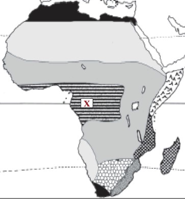
Q-7 Select the correct alternatives with respect to the map given:
(i) The chief characteristic of the climate at X is a. heavy rainfall b. cool summer c. warm winters d. a summer drought e. a large temperature range
(ii) The area shaded on the map is a. Mediterranean Region b. Savanna c. Tropical Desert d. Equatorial Region
(iii) Which statement is NOT true of the Sahara Desert? a. is in northern Africa b. is crossed by the Equator c. is the largest desert in the world d. has little vegetation
(iii) Which statement is NOT true of the Sahara Desert? a. is in northern Africa
Q-8 State the role of the following people involved in the cocoa business
(i) Farmers
(ii) Traders and exporters
(iii) Grinders
(iv) Chocolate and beverage companies
Q-9 Fill in the Blanks:
(i) Cocoa is the chief _________ export of Ghana and the country's main ______ crop.
(ii) Cocoa production occurs in the Ghana's forested areas where rainfall is _________ mm per year.
(iii) Cocoa bean is known as Ghana's _________________, _______________ .
(iv) The key players in the cocoa business are ________, ________________, _________ and __________ .
(v) Companies like ______________, ______________ and________________, produce chocolate and beverages for the final consumers.
(v) Companies like __________________ and________________, produce chocolate and beverages for the final consumers.

(v) Companies like __________________ and _______________, produce chocolate and beverages for the final consumers.

(iv) The key players in the cocoa business are ________ _ _________ and __________ .
(iii) Cocoa bean is known as Ghana's _________________ .
Q-10 Arrange the stages in the cultivation and harvesting of cocoa in correct order.
(i) The pods are opened to remove the beans.
(ii) The cocoa beans undergo a drying process.
(iii) Ripe pods are removed from the trees.
(iv) The beans are bagged for delivery.
(v) The cocoa beans are fermented in boxes.
Q-11 Explain why:
(i) The cocoa pods must be harvested at regular intervals.
(ii) Cocoa bean is known as Ghana's black gold.
(iii) Many Ghanaian farmers have incomes below the poverty line.
(iv) Cocoa farmers are now planting non cocoa trees on their cocoa farms.
(v) The pods are opened to remove the beans within a week to ten days after harvesting.
Q-12 State whether the statements are true or false. Correct the incorrect statement.
(i) Ghana is the largest cocoa exporter in the world.
(ii) Cocoa production occurs in the country's forested areas where rainfall is 500-700 mm per year.
(iii) The crop year begins in October, with a smaller mid-crop cycle beginning in July.
(iv) Pods containing cocoa beans grow from the branches of the cocoa tree.
(v) Cocoa is the main food crop of Ghana.
Chapter-9   Australia
Q-1 Answer the following questions.
(1) State the latitudes and longitudes within which Australia lies.
(2) Label the capital city indicated by black dots on the map given below.
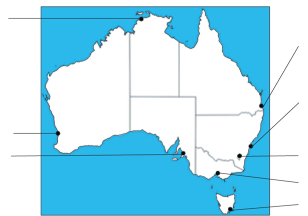
Q-2 Label the following :
(a) Label the political features numbered 1 to 8.
(b) Label the physical features numbered A to F.
(b) Label the physical features numbered A to F
Q-3 Name or State:
(i) The full official name of Australia.
(ii) The strait that separates Australia from Tasmania.
(iii) The world's largest coral reef.
(iv) Two rocky ranges in the Western Plateau.
(v) The most famous high point in the Western Plateau.
(vi) The most important river system of Australia.
(vii) The highest peak in the Eastern Highlands.
(viii) The water body that forms an arch along the southern coast.
(ix) A gulf in southeastern Australia.
(x) A bay in southeastern Australia.
Q-4 Give Reasons:
(i) Australia is known as an island continent.
(ii) Lake Eyre Basin is an area of inland drainage.
(iii) The Eastern Highlands are known as the Great Dividing Range.
(iv) There are very few natural harbours in Australia.
(v) The eastern coastal plains of Australia have fertile farmlands whereas the western coastal plains have scanty vegetation.
Q-5 Answer the following questions.
(i) What is the Great Barrier Reef? How was the Great Barrier Reef formed?
(ii) Why is the Great Barrier Reef recognised as a World Heritage site?
Q-6 Answer the following questions.
(i) What is an artesian well?
(ii) What are the four conditions necessary for artesian wells to occur?
Q-7 Fill in the blanks:
(i) The Great ______________ forms an arch along the eastern coast of Australia.
(ii) The _________ Sea separates Australia and New Zealand.
(iii) The __________________ extends over two-thirds of Australia.
(iv) The __________________ Plain has Australia's most fertile farmlands.
(v) The western edge of the Western Plateau slopes ________ (gently/steeply) to the sea.
(vi) The _________ Plain is spread along the southern coast of Australia. Its soil is composed of _____________ .

(vii) The _________ mountains, the _________ Alps, and the ________ _________ Plateau are some of the smaller ranges of the Great Dividing Range.

Q-8 Answer briefly:
(i) Where is the British type of climate found in Australia?
(ii) Which part of Australia has the Mediterranean type of climate?
(iii) What type of agriculture is carried on in the temperate grasslands?
(ii) Which part of Australia has the Mediterranean type of cl imate?
Q-9 Explain why:
(i) Australia celebrates Christmas in summer.
(ii) Most of the sheep are reared in the temperate zone in South Queensland.
(iii) Sheep are sheared in summer.
Q-10 Fill in the blanks:

(i) The__________, is called porcupine grass because it has the appearance of needles.

(ii) The temperate grasslands of Australia are known as the _____________ .
(iii) The kangaroo is a _________ , which means that the mother carries its young in a skin pouch under her belly.
(iv) _________ is the only carnivorous animal of Australia.
(v) Paid workers on a sheep station are known as ___________ .
(vi) Sheep stations are divided into large fenced fields called _____________ .
Q-11 Name or State:
(i) Three of Australia's unique animals.
(ii) The most common and abundant type of tree found in Australia.
(iii) A mammal that lays eggs.
(iv) The native bear of Australia.
(v) The type of sheep which gives very good quality wool and are reared in Australia.
(vi) Three important wool markets in Australia.
(vii) A flightless bird of Australia.
(viii) The bird known as the 'laughing jackass'.
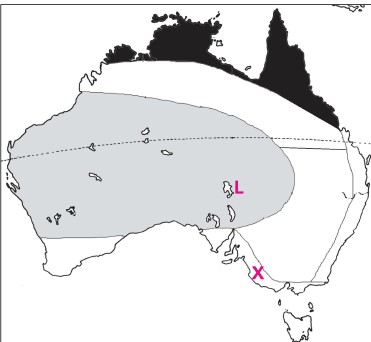
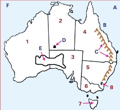
Q-12 Study the map alongside and answer the following questions:
(i) Name lake L.
(ii) Shade the area of inland drainage.
(iii) Name the natural region shaded black.
(iv) What is the chief characteristic of the climate at X?
(v) The natural vegetation in the shaded area grey.
Chapter-10   Antarctica
Q-1 Answer the following questions.
(1) Name the explorer who first reached the South Pole.
(2) Why was the continent named "Antarctica"?
(3) What is the nature or type of research that is conducted in Antarctica?
Q-2 Fill in the blanks:
(i) Antarctica was sighted in the year _____________ .
(ii) The _________ Mountains divide Antarctica into two parts.
(iii) Antarctica's most active volcano is found on _________ Island.
(iv) India's second permanent station Maitri is established at _________ Ranges.
(v) India's first scientific station in Antarctica is named ___________________ .
Q-3 Give reasons for the following:
(i) Antarctica is known as the White Continent.
(ii) There is a great difference between the temperature in the coastal areas and at the centre of the ice-cap.
(iii) Antarctica is a cold desert.
(iv) None of Antarctica's mineral resources have been developed.
(v) Antarctica is an important key in the understanding of global and environmental concerns.
(vi) Antarctica is extremely unsuitable for permanent habitation.
Q-4 State whether the following statements are true or false
(i) 99% of the continent of Antarctica remains permanently covered with ice.
(ii) The Antarctic Peninsula is a mountainous, S-shaped finger of land that points towards Australia.
(iii) Antarctica is the coldest of all the continents.
(iv) Most land animals in the Antarctica live at the edges of the continent.
(v) There are no cities or villages in Antarctica.
(vi) The ocean has plenty of wildlife.
Q-5 Name/state the following:
(i) Two continents smaller than Antarctica.
(ii) India's permanent base camp in Antarctica.
(iii) Antarctica's most active volcano.
(iv) The highest mountain peak in Antarctica.
(v) The peninsula that forms a continuation of the Andes Mountain chain of South America.
(vi) The summer months in Antarctica.
(vii) The two most common plants found in Antarctica.
(viii) The most common animal of the ocean.
(ix) The two Indian scientific stations in Antarctica.
(x) The chemical that is the major cause of the ozone hole over Antarctica.
(xi) The first Indian woman to go on a scientific expedition to Antarctica.
(xii) The countries that have five research stations each in Antarctica.
(xiii) The largest research station in Antarctica.
(xiv) The chemicals responsible for the ozone hole over Antarctica.
(xv) Write the expanded form of IGY.
(xvi) The lowest recorded temperature in Antarctica.
(xvii) The winter months in Antarctica.
(xviii) The country which has the largest research station in Antarctica.
(xix) The average winter temperatures in the interior and on the coast.
(xx) The average summer temperatures in the interior and on the coast.
(xxi) The average annual precipitation in the interior.
(xxii) The average annual precipitation along the coast.
(xxiii) The mountains where Mt. Erebus is located.
(xxiv) The mountains where Vinson Massif is located.
(xxv) The mountains that divide Antarctica into East Antarctica nd West Antarctica.