Question bank

Chapter-1   Interpretation of Topographical Maps -1
Q-1 Identify the landform from the description given:
(i) The contours are spaced close together and may merge into one another.
(ii) A deep valley with steep sides, often with a stream flowing through it.
(iii) An upland region with a steep slope on one side and a gentle slope on the other.
(iv) Evenly spaced contour lines.
(v) Contour lines are closely spaced.
Q-2 Put a tick against the correct statement:
(i) Contour lines form 'V' shapes in streams. The closed end of the 'V' points upstream.
(ii) A contour line that forms a closed loop with no other contour lines inside indicates a hilltop.
(iii) Widely spaced contour lines indicate gentle slopes of relatively flat land.
(iv) Contour lines can sometimes split or divide.
(v) Contour lines never end except at the edge of a map.
(vi) Concentric circles with hachure marks on contour lines indicate a small closed depression.
(vii) Streams on each side of the water divide flow in opposite directions.
(viii) Contour lines form a 'V' when they cross a stream or canyon, and the apex of the 'V' points to the higher ground. Therefore, a stream will flow opposite to the apex of the 'V'.
(ix) All points along a contour line represent a single elevation.
(x) Waters on each side of a divide never meet, but may flow into the same ocean.
(xi) In a river basin, all the water drains into a large river whereas in a watershed the water drains into a stream, lake or wetland.
(xii) A watershed is the topographical boundary dividing two adjacent catchment basins.
(xiii) A gorge is a deep cleft between escarpments and cliffs resulting from weathering and the activity of a river over geologic time scales.
(xiv) The contour interval and vertical interval always have the same numerical value.
(XV)A tropographical map is a small scale map .
Q-3 Based on G43S7 - facing WB page 228 (Eastings 21 to 30; Northings 01 to 12)
(1). Name the most important perennial source of irrigation shown on the map extract.
(2). Give two points in evidence to show that the region in the map extract has seasonal rainfall.
(3). Name two types of vegetation given in the extract.

(4). (i)  How many types of tracks are shown in the map extract? Name them. (ii) What is the common mode of transportation in the southern part of the map?

(5). What is the general pattern of the settlement? Explain.
(6). What is the general land use of (i) uneven ground and (ii) even ground?
(7). Give two items of evidence the map provides to indicate that the area shown has seasonal rainfall?
(8). Name one area on the map not suited for agriculture.

(4).  How many types of tracks are shown in the map extract? Name them. (ii) What is the common mode of transportation in the southern part of the map?

(4). (i) How many types of tracks are shown in the map extract? Name them. (ii) What is the common mode of transportation in the southern part of the map?
Q-4

Based on G43S7 - facing WB page 234 (Eastings 30 to 38; Northings 01 to 12)

(1). (i) What does .201 in the grid square 3005 mean? (ii) What do you mean by 20r in the grid square 3406?

(2). (i) What does the blue line in the Varka Nadi indicate? (ii) What is the general direction of the Varka Nadi?

(3). (i) What is the meaning of 1 :50,000 printed below the map extract? (ii) Calculate the distance in kilometres along the cart-track between Jegol in grid square 3002 and Odhava in grid square 3304.
(4). What is the pattern of drainage in the grid square 3011?
(5). What is the chief occupation of the people living in the area shown in the map extract? What evidence i---c-~~ does the map provide for your answer?
(6). What is the chief form of irrigation shown on the map extract? What evidence does the map provide for your answers?

2. (i) What does the blue line in the Varka Nadi indicate? (ii) What is the general direction of the Varka Nadi?

(2). (i) What does .201 in the grid square 3005 mean? (ii) What do you mean by 20r in the grid square 3406?
Q-5 Based on G43S 10- facing WB page 240 (Eastings 63 to 72; Northings 28 to 39)

(1). Give a six figure grid reference for the peak of Bhuni Magri Hill.

(2). What kind of road connects Gulabganj to Sirori?
(3). How does the road from Gulabganj to Sirori across the Sipu Nadi?
(4). Write down the grid number of the region where you can see considerable perennial water. What is the maximum height of the wall impounding water in the tank?
(5). State two important sources of irrigation water in the region. What inference do you draw from this about the main occupation of the people?
(1). Give a six figure grid reference for the peak of Bhuni Magri Hill.
Q-6 Based on G43S 10- facing WB page 243 (Eastings 63 to 72; Northings 14 to 25)
(1). Give the meaning of the conventional symbol printed on the map of 652148 six figure grid reference.

(2). Name the type of drainage pattern found in grid 6317.

(3). What are the brown lines covering most of the map extract called? What do these brown lines indicate?
(4). What do the words "falls 25 m" in grid square 6918 mean?
(5). What would be the main source of water supply for Mt. Abu? Give a reason for your answer.
(6). There are no roads connecting Mt. Abu to the settlements in the southwest. Why?
(7). Name any two types of forested regions mentioned in the map extract.
(8). What is the settlement pattern of the largest town on the map extract supplied to you?

(9). Describe the nature of the roads connecting Gautam Maharishi Mandir 6518 and Shri Vashist Ashram 6719 .

(10). What according to you is the religion of the people in this area?
(9). Describe the nature of the roads connecting Gautam Maharishi Mandir 6518 and Shri Vashist Ashram 6 7 1 9 .
(2). Name the type of drainage pattern found in grid 631 7.
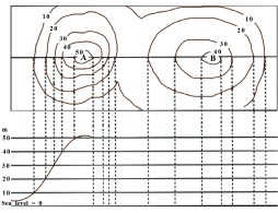
Q-7 With respect to the diagram given:
(i) Complete the diagram below the topographic map with proper elevations.
(ii)Colour the elevations as under: Red : 50 m or higher , Orange : 40-50 m , Yellow : 30-40 m , Light green : 20-30 m , Dark green : 1 0-20 m , Purple:0-10 m
(iii) How many metres of elevation a re there between contour lines on the topographic map?
(iv) Which hill is higher?
(v) Which hill has a steeper slope?
How many metres of elevation
Colour the elevations as under: Red Orange Yellow : 50 m or higher : 40-50 m 30-40 m Light green : 20-30 m Dark green : 1 0-20 m ,
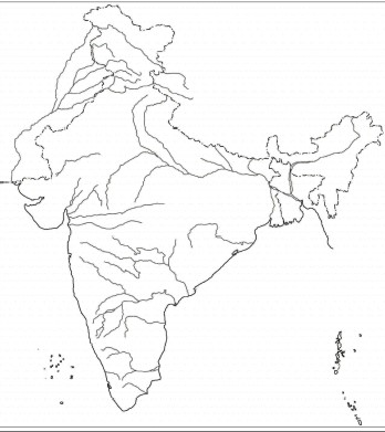
Chapter-2   Maps of India
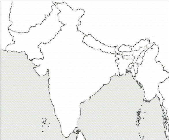
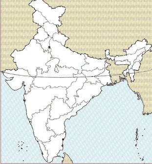
Q-1 On the map of India given below :
(i) Draw and name the Tropic of Cancer
(ii) Label the rivers Godavari and Chenab.
(iii) Mark and name the Garo Hills and Khyber Pass.
(iv) Mark C on the coalfields in Jharia.
(v) Mark with an arrow and name the NE monsoon over the Bay of Bengal.
(vi) Shade and name the Gulf of Kachchh.
(vii) Shade and name the coastal plain that receives rainfall in October - November.
(viii) Mark with a dot and name Delhi and Chandigarh.
(ix) Shade a region with Black cotton soil.
(x) Use an arrow to point at a densely populated state in South India.
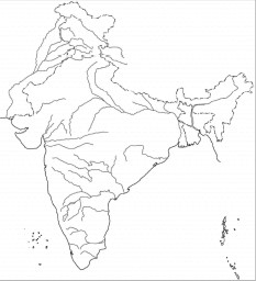
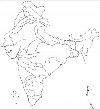
Q-2 On the map of India given below :
(i) Draw and number the Standard Meridian of India.
(ii) Label the river Mahanadi.
(iii) Mark and name Lake Chilika.
(iv) Shade and name the Gulf of Mannar.
(v) Mark and name the Vindhya Mountains.
(vi) Shade and name a sparsely populated region in western India.
(vii) Shade a region with alluvial soil in South India.
(viii) Mark and label Kolkata and Hyderabad.
(ix) Mark with arrows and name Southwest Monsoon winds over the Bay of Bengal.
(x) Mark and name Mumbai High.
Q-3 On the map of India given below :
(i) Mark and name the Nilgiris.
(ii) Shade and label the Malwa Plateau and the Nilgiri hills.
(iii) Shade and label the Malabar Coastal Plains.
(iv) Mark and name the river Gomti.
(v) Shade and name the Andaman Sea.
(vi) Mark and name Allahabad.
(vii) Mark with a single arrow and name the winds that bring winter rain to northwest India.
(viii) Mark and name Digboi.
(ix) Mark an area with laterite soil below the Tropic of Cancer.
(x) Mark and name the Karakoram Pass.
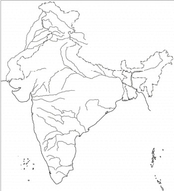
Q-4 On the map of India given below :
(i) Shade and label the Jaintia hills.
(ii) Label the river Yamuna.
(iii) Shade and name the Gulf of Khambhat.
(iv) Mark and name the Nathu La Pass.
(v) Shade and name the Andaman Sea.
(vi) Shade and name a sparsely populated state in Northeast India.
(vii) Shade a region with laterite soil in Eastern India.
(viii) Mark with a dot and name Visakhapatnam.
(ix) Mark and label Mt. Kanchenjunga and the Shiwalik range.
(x) Print S on the iron mine in Singhbhum.
Q-5 On the map of India given below :
(i) Mark and name Chennai.
(ii) Shade the area of the Western Disturbances.
(iii) Shade and label the Chhota Nagpur Plateau.
(iv) Mark and label 82.5°E Meridian.
(v) Mark and name the lndo-Gangetic Plains.
(vi) Shade and label an area with Red Soil.
(vii) Mark and name the winds which bring rain to Mumbai in July and August.
(viii) Mark and name the Satpura Range.
(ix) Label the river Tapi.
(x) Shade and label the Northern Circar coastal region.
Q-6 On the map of India given below :
(i) Shade and label the Thar Desert and the Sundarbans.
(ii) Label the river Narmada.
(iii) Label the river Satluj.
(iv) Mark and name the Aravali Mountains.
(v) Mark and label Bengaluru.
(vi) Shade and name a region with Black soil.
(vii) Mark and name the winds which bring rain in winter to the Coromandel Coast.
(viii) Mark with a dot and name Srinagar.
(ix) Label the river Kosi.
(x) Shade and name the Deccan Plateau.
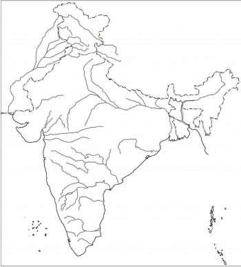
Q-7 On the map of India given below :
(i) Mark and name Kochi.
(ii) Label the river Krishna.
(iii) Label the river Chambal.
(iv) Mark and label the Konkan Coast and the Eastern Ghats.
(v) Shade and label an area of laterite soil in North India.
(vi) Shade and label an alluvial soil area in Peninsular India.
(vii) Mark with arrows the direction of the Arabian Sea branch of Southwest Monsoon Winds.
(viii) Shade and label the Western Ghats.
(ix) Mark and label the K2 peak.
(x) Mark and label the Wular lake.
Chapter-3   Location , Extent and Physical Features of India
Q-1 Answer the following questions
(a). Name the two main mountain ranges that constitute the Great Mountain Wall of the North.

(b). In which of the ranges named in the following located?

(i) K2 peak

(ii) Himadri range

(iii) Baltoro glacier

(iv) Gangotri

(v) Shiwalik ranges

(vi) Shimla 

(b). In which of the ranges named in the following located? (i) K2 peak (ii) Himadri range (iii) Baltoro glacier (iv) Gangotri (v) Shiwalik ranges (vi) Shimla 

(b). In which of the ranges named in (a) are the following located? (i) K2 peak (ii) Himadri range (iii) Baltoro glacier (iv) Gangotri (v) Shiwalik ranges (vi) Shimla 

(b). In which of the ranges named in (a) are the following located? (i) (iv) K2 peak Gangotri (ii) Himadri range (v) Shiwalik ranges (iii) (vi) Baltoro glacier Shimla
Q-2 Match the items in column A with the appropriate items in column B
Q-3 By what name is the Brahmaputra known in:
(i) Tibet
(ii) Bangladesh
Q-4 Answer the following questions.
(a) Name the two river basins that make up the Northern Plains.

(b) Pick out the odd member and give a reason for your selection.

(i) Chenab, Jhelum, Ravi, Beas, Yamuna

(ii) Tista, Ghaghara, Gandak, Kosi, Jamuna

(iii) Son, Chambal, Betwa, Yamuna, Damodar

(b) Pick out the odd member and give a reason for your selection. (i) Chenab, Jhelum, Ravi, Beas, Yamuna (ii) Tista, Ghaghara, Gandak, Kosi, Jamuna (iii) Son, Chambal, Betwa, Yamuna, Damodar
Q-5 Answer the following questions.
(a). State the location of the Great Indian Desert.
(b) Name one important: (i) River in this region (ii) Salt water lake in this region
Q-6 State the importance of the following:
(i) The Northern Wall
(ii) The Northern Plains
Q-7 Answer the following
Mention two differences between the Western Himalayas and the Eastern Himalayas.
Q-8 Fill in the blanks
(i). The Western Himalayas are located between the ______ river and the ______ river.
(ii). ______ are the oldest mountains of the subcontinent.
(iii). ______ is the most important pass of the subcontinent.
(iv) ______ in the Himalayas is the source of the Ganga.
(v). ______ and ______ are important tributaries of the Ganga.

(vi) The Eastern Plain comprises of the __________ in Assam.

(vii) The rivers ______ and ______ join together in ______ to form the largest delta in the world.

(viii) The confluence of the Ganga, Yamuna and Sarasvati is known as __________

(ix) The ______ makes up the highest part of the Himalayas.
(x) The highest peak in india is the. __________________
(viii) The confluence of the Ganga, Yamuna and Sarasvati is known as ___________ _
(vi) The Eastern Plain comprises of the ___________ _ ______ in Assam.
Q-9 Name :
(i) The highest peak of the Western Ghats.
(ii) The longest river of the Deccan Plateau.
(iii) The highest peak of the Eastern Ghats.
(iv) A river of the Peninsular Plateau that does not form a delta.
(v) A braided river.
(vi) The longest river in India.
Q-10 Explain why:
(i) The Peninsular Plateau of India is rich in mineral resources.
(ii) The Narmada and Tapi do not form deltas.
(iii) The rivers of the Deccan Plateau are non perennial and non navigable.
(iv) The Brahmaputra is called the "Red River".
(v) The Damodar is called the "Sorrow of Bengal".
(vi) The Northern Plains of India are one of the most densely populated regions of the world.
(vii) The Brahmaputra is a braided river.
(viii) The delta region of the Indus is largely a wasteland.
(ix) The Ganga is navigable from its mouth right up to Haridwar.
(viii) The delta region of the Indus is largely a wastelan
Q-11 State whether the following statements are true or false. Correct the incorrect statement.
(i) India has a fairly regular coastline.
(ii) Lakshadweep is a group of islands in the Bay of Bengal.
(iii) The Gulf of Khambhat separates India from Sri Lanka.
(iv) Minicoy belongs to the Andaman and Nicobar group of islands.
(v) The Gulf of Kachchh is found along the coast of Gujarat.
(i) (i) India has a fairly regular coastline.
Q-12 Answer the following
(i) Name the river that divides the Peninsular Plateau of India into two parts.
(ii) Name the two parts of the Peninsular Plateau of India.
(iii) Name the landforms that form the boundaries of each of the parts named in (ii).
Q-13 By what name are the Western Ghats known in:
(i) Maharashtra
(ii) Karnataka
(iii) Kerala
Q-14 Name two rivers of the Peninsular Plateau that flow:
(i) Eastwards
(ii) Westwards
Q-15 List three differences between the following:
(i) Western Ghats and Eastern Ghats.
(ii) Rivers of Northern India and rivers of Peninsular India.
(iii) West coast of Peninsular India and East coast of Peninsular India.
Q-16 State two characteristics of each of the following:
(i) Western Coastal Plain
(ii) Eastern Coastal Plain
Q-17 Answer these questions:
State the importance of the Coastal Plain.
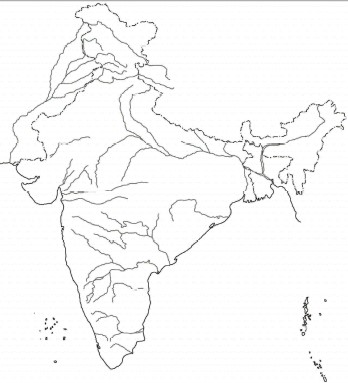
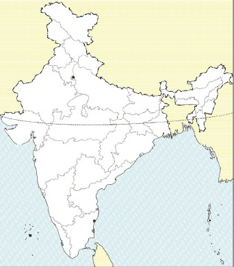
Q-18 On the map provided, do as instructed:
(i) Shade the countries that share a border with India and name them.
(ii) In the box provided, write the latitudinal east-west extent and longitudinal north-south extent of India.
(iii) Draw the Standard Meridian of India and mark and label Allahabad on it.
Q-19 On the map provided, do as instructed:
(i) Label the Gulf of Mannar, Andaman Sea, Gulf of Kachchh and the Gulf of Khambhat.
(ii) Shade and label the following ranges: Vindhyas range, Aravali range, Satpura range.
(iii) Mark and label the Karakoram Pass and the Nathu La Pass.
(iv) Shade and label the Thar Desert.
(v) Mark with a dot and label the following cities: Delhi, Mumbai, Srinagar, Kolkata, Chennai, Hyderabad, Bengaluru, Kochi, Chandigarh and Visakhapatnam
(vi) Shade and label the Garo, Khasi and the Jaintia hills.
(vii) Colour in pink the three largest states.
(viii) Colour in yellow the three smallest states.
(ix) Colour in blue the state that has the highest population.
(x) Colour in green the state that has the lowest population.
(xi) Mark and label the water body that separates India from Sri Lanka.
Q-20 On the outline map of the Indian subcontinent:
(i) Label the following rivers: Indus, Ravi, Beas, Satluj, Jhelum, Chenab, Ganga, Yamuna, Ghaghara, Gomti, Gandak, Kasi, Chambal, Betwa, Son, Mahanadi, Damodar, Krishna, Kaveri, Narmada, Godavari, Tapi, Luni, Brahmaputra.
(ii) From the above rivers, a. Name the rivers that rise in the Himalayas. b. Name the rivers that empty into the Bay of Bengal. c. Name the rivers that empty into the Arabian Sea. d. The rivers that drain the areas of Punjab and Haryana states. e. Name the rivers that rise in the Western Ghats.
(iii) Mark and label the Wular lake and the Chilika Lake.
(iv) Shade and name the Ganga Plain.
(v) Mark and label the ranges that divide Peninsular India from the Northern Plains.
Chapter-4   Climate of India
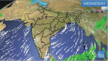
Q-1 Study the weather pattern shown in the weather Channel report given below and answer the questions :
(i) What is the direction of the winds shown in the report?
(ii) Are these winds offshore or onshore winds?
(iii) Mark and label HP, a region of high pressure on the map.
(iv) Name the season being experienced in India and give three evidence to support your answer.
(v) Name the months of the year during which these conditions prevail over India.
(vi) Describe the climatic conditions in northern India during this period.
(vii) Name two areas in India to which these winds would bring rain.
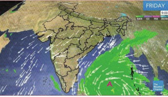
Q-2 Study the weather pattern shown in the Weather Channel report given below and answer the questions:
(i) A circular movement of air is seen at A over the green patch at the head of the Bay of Bengal. What is it called? Why does it occur?
(ii) To which parts of does it bring rain?
(iii) State the effects phenomenon on the Indian subcontinent, especially India.
(iv) During which month/s of the year does it normally occur?
Q-3 Explain why:
(i) Thiruvananthapuram is warmer than Agra in December.
(ii) The SW Monsoons approach Uttar Pradesh from the east.
(iii) Delhi has a high annual range of temperature.
(iv) Shillong experiences less rainfall than Cherrapunji.
Q-4 Answer the following
(a) Why do the SW Monsoons retreat?
(b) State the characteristics of the following: (i) Advancing SW Monsoon season (ii) Retreating SW Monsoon season
(c) Differentiate between the Retreating SW Monsoon and the NE Monsoon.
(b)State the characteristics of the following: (i) Advancing SW Monsoon season (ii) Retreating SW Monsoon season
c. Differentiate between the Retreating SW Monsoon and the NE Monsoon.
b. State the characteristics of the following: (i) Advancing SW Monsoon season (ii) Retreating SW Monsoon season
a. Why do the SW Monsoons retreat?
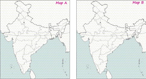
Q-5 With respect to the outline maps given below, do as directed:
(i) On map A draw arrows to show the normal onset of SW Monsoon winds on 10 June.
(ii) Name and label the Arabian Branch of the SW Monsoon winds.
(iii) Name and label the Bay of Bengal Branch of the SW Monsoon winds.
(iv) On map A draw arrows to show the SE Monsoon winds.
(v) Name four states that receive rainfall by 10 June.
(vi) On map B draw arrows to show the SW Monsoon winds on 15 October.
(vii) Shade the region on map B which gets the maximum number of rainy days in India.
(viii) On map A shade the region in India which does not get any rainfall from the SW Monsoon winds.
(ix) Circle an area on map B in India which is the first to receive rain from the Bay of Bengal Branch.
Q-6 Pick the odd one out:
(i) Heavy rainfall ( > 400 cm) : Western slopes of Western Ghats, West Coastal Plains, Upper l;/;;;;:r,;,,,,it:,,1.K1:"::, Ganga Valley, Cherrapunji, southern slopes of Eastern Himalayas, 1.:;c,cct;:,,;;,;,; ::IJ;;;;;;;; Arunachal Pradesh, Assam.
(ii) Heavy Rainfall (200cm-400cm) : Assam, Ganga Delta, Western Ghats, Arunachal Pradesh, Tripura, Punjab, Nagaland, Himachal Pradesh.
(iii) Moderate Rainfall (100cm-200cm) : Middle Ganga Valley, Odisha, eastern slopes of Western Ghats, eastern Maharashtra, Deccan Plateau, Madhya Pradesh, northern part of Andhra Pradesh, eastern part of Tamil Nadu.
(iv) Low Rainfall (50cm-100cm) : Upper Ganga Valley, eastern Rajasthan, Punjab, Haryana, Jammu and Kashmir, Deccan Plateau, Assam.
(v) Scanty Rainfall ( < 50cm) : Northern part of Kashmir, Himachal Pradesh, south-western Punjab, western Rajasthan, rainshadow regions of Western Ghats.
Q-7 Answer the following questions.
(1) Mangaluru and Chennai lie on the same latitude, yet Mangaluru receives its rainfall from June-September while Chennai receives most of its rain in November-December . What are the reasons of this difference.
(2) Why is the diurnal range of temperature during summer greater at Bikaner (Rajasthan) than at Panjim (Goa)?
(3) Give two reasons as to why Thar is a desert area.
(4) At a place like Bhopal, one can see the midday Sun exactly overhead twice a year, while at Vidisha, only a few kilometres north of it, one is not able to see it even once. Give reason.
(5) Study the table given below and answer the questions that follow: (i) Calculate the annual rainfall in Station A. , (ii) What is the annual range of temperature in Station B. , (iii) Name the winds that bring most of the rainfall to Station B. State one reason of your answer.
(6) Study the climate data given below and answer the questions that follow: (i) Calculate the mean annual temperature . (ii) What is the total rainfall during the monsoon season? (iii) Does the Station have a maritime or a continental climate ? give reason of your answer.
(7) Give two important characteristics of the South West Monsoon rainfall.
(8) Name two types of cyclonic systems that affect India and two areas that receive rainfall from these systems.
(9) Give reason for the following: (i) When the malabar Coast is receiving heavy rainfall in july the Tamil Nadu Coast is Comparatively dry. (ii) The Northern Plains of India have a continental type of climate . (iii) Central Maharastra receives little rainfall.
(10) Study the climatic data given below and answer the questions that follow: (i) Calculate the annual rainfall experienced by the station. (ii) Suggest a name of this station, giving a reason for your answer.(iii) Name the season during which the rainfall is harvested.
(11) Mention a geographical reasons for each of the following: (i) Patna receives heavier rain than Delhi. (ii) Western Rajasthan receives no ran from the Arabsan Sea branch of the Southwest Monsoon winds. (iii) Mangaluru is not cold even in the month of December.
(10) Study the climatic data given below and answer the questions that follow:
(9) Give reason for the following
(6) Study the climate data given below and answer the questions that follow:
(5) Study the table given below and answer the questions that follow:
(1) Mangaluru and Chennai lie on the
Q-8 Answer the following questions.
(1) Explain why the climate of India is known as 'Monsoonal'.
(2) Why are the Himalayas called the perfect climate divide? Explain the two-fold function in this regard.
(3) Describe the four phenomena, responsible for the weather condition in India, which lie much beyond its geographical limits.
(4) How are the sources of rainfall in the North-West part of India different from the rainfall experienced in the coastal areas of Eastern India in winter?
(5) List the characteristics of the cold weather season.
(6) Name the seasons during which the Northeast Trade winds dominate the Indian Sub-Continent.
(7) Account for the storms during the Hot - Weather Seasons.
(8) Despite the broad climate unity, the climate of India has many regional variations. Justify this statement giving suitable examples.
(9) Explain the mechanism of the Westerly depressions.
(10) a. What is meant by 'rainshadow' area? b. Give two examples of 'rainshadow' areas in India.
(11) State two differences between tropical cyclones and temperate cyclones.
Q-9 State briefly how the following factors influence the climate of India.
(i) Latitude
(ii) Distance from the sea
(a) Why do the SW Monsoons retreat?
(b) State the characteristics of the following: (i) Advancing SW Monsoon season (ii) Retreating SW Monsoon season.
(a) a. Why do the SW Monsoons retreat?
Q-10 Explain the role of the Himalayas in determining the climate of India during:
(i) The cold weather season
(ii) During the period of the SW Monsoon season.
(iii) The hot weather season.
(iv) During the period of the retreating SW Monsoon season.
(iii) The hot weather season
Q-11 Name the months of the following
(i) Cold weather season
(ii) Hot weather season.
(iii) SW Monsoon season.
(iv) Retreating SW Monsoon season.
(iv) Retreating SW Monsoon season. \
Q-12 Explain why:
(i) Thiruvananthapuram is warmer than Agra in December.
(ii) The SW Monsoons approach Uttar Pradesh from the east.
(iii) Delhi has a high annual range of temperature.
(iv) Shillong experiences less rainfall than Cherrapunji.
(v) Punjab gets winter rainfall.
(vi) Bikaner has a high diurnal range of temperature.
(vii) Thar gets little or no rainfall.
(viii) Western Rajasthan is the region with the lowest pressure in May.
(ix) Tamil Nadu gets winter rain.
(x) Chennai has more rainy season months but less rain than Mumbai.
(xi) The monsoon rain is unevenly distributed over India.
(xii) Most of the rainfall of the Indian subcontinent is received only in the four months of the year.
(xiii) The lndo-Gangetic plain gets some rain during December and January.
(xiv) The Coromandel coast gets most of its rain during the winter season.
Q-13 A cricketer at Chennai (Madras) from October 24 to 28 had to be abandoned because of bad weather all through. Give a geographical reason. Ensure that your explanation provides:
(i) The technical name for this season in India.
(ii) The atmospheric pressure conditions over the Bay of Bengal during this part of the year.
(iii) The typical rainfall regime experienced in Chennai.
Q-14 Name the months during which the following occur:
(i) Kalbaisakhi
(ii) Mango Showers
Q-15 Answer the following
(a) Why do the SW Monsoons retreat?
(b) State the characteristics of the following: (i) Advancing SW Monsoon season (ii) Retreating SW Monsoon season
(c) Differentiate between the Retreating SW Monsoons and the NE Monsoons
(b) State the characteristics of the following:
Q-16 Answer the following
(i) Give the latitudinal and longitudinal extent of the Indian subcontinent.
(ii) Give two reasons why Jaipur has a higher annual range of temperature than Mumbai.
(iii) a. Which winds are responsible for the rainfall experienced over the greater part of the Indian subcontinent? b. During which months of the year is this rainfall experienced?
(iv) a. What are 'Western disturbances'? b. Name two states that experience these 'Western disturbances'.
(v) What is meant by Kalbaisakhi?
Q-17 With reference to the climatic conditions in India briefly answer the following questions:
(i) Why does Kanniyakumari experience an equable climate?
(ii) Why has Chennai a lower annual range of temperature than Lucknow?
(iii) Give one reason to justify that the Himalayas act as the 'Climate Divide'.
(iv) What is the cause of winter showers in Western Uttar Pradesh and Punjab?
(v) Why does central Maharashtra get a light rainfall?
Q-18 Name:
(i) One region that gets rainfall from the Retreating Monsoons.
(ii) Two local winds that blow in India in the summer months.
(iii) A region in India that gets most of its rain during the winter season.
(iv) A place in India that receives the heaviest rainfall.
(v) A region which gets very little rain from the summer monsoon.
(vi) The winds that bring rain to the Tamil Nadu coast.
(vii) An area in India which gets more than 200cm of rainfall.
(viii) Explain how rainfall influences the economy of India.
(ix) The SW Monsoon winds before they cross the equator.
(x) Two branches of the Southwest Monsoon winds.
Q-19 State the economic importance of :
(i) Relief rain in Tamil Nadu.
(ii) Cyclonic rainfall in Punjab.
(iii) Kalbaisakhi in West Bengal and Assam.
(iv) Mango showers in Kerala and Karnataka.
Q-20 On the map of the subcontinent, do as instructed:
(i) Use arrows to show the two branches of the SW Monsoons.
(ii) Shade the areas that receives more than 200cm of annual rainfall.
(iii) Use dots to show an area affected by Kalbaisakhi.
(iv) Write 'A' at the place to first receive the Monsoon rains.
(v) Shade the area that gets rain during the Winter Monsoons.
(vi) Use arrows to show the direction of winds in the Ganga Plain during the NE Monsoons.
(vii) Encircle areas of very scanty rainfall.
(viii) Write 'B' where the Monsoons arrive last.
(ix) Show the area that experiences cyclonic rain during the month of October.
Chapter-5   Soil Resources in India
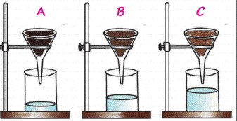
Q-1 The experimental set up as shown below was left for a day. The amount of water collected in the beaker was then noted. Answer the questions given below:
(i) Identify A, B and C and support your answer with suitable reason.
(ii) Which of the named soils would be best suited for growing fruits and vegetables? Explain why.
(iii) Which of these soils when combined in equal proportion, forms loamy soil? A+ B , A+C , B + C
(iv) Which of the named soils would be best suited for growing crops? Explain why.
(v) Which of the named soil is transported soil? How is it transported?
(vi) Which of the named soil is formed in situ by the weathering process?
(vii) Name three soil groups that are formed in situ.
(viii) Name one naturally occuring organic soil component that greatly enhances the fertility of soil. How is it formed?
(ix) What is the source of the minerals present in soil?
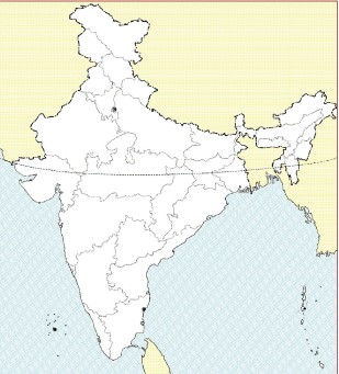
Q-2 Shade a small area on the map given (using appropriate colours):
(i) A soil formed as a result of volcanic activity.
(ii) A soil formed due to leaching.
(iii) A soil formed by the weathering of metamorphic rocks.
(iv) A soil formed by the deposition work of rivers.
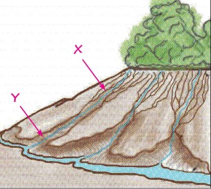
Q-3 The sketch below shows the hill slopes devoid of vegetation.
(a) Which of the following statements are true in case trees were present: (i) Trees would hold the soil together so it would not be easily removed by running water and wind. (ii) Trees would reduce the speed of flowing water and allow the water to be absorbed by the soil. (iii) Trees would reduce the force of strong winds and prevent the blowing away of soil particles. (iv) All of the above.
(b) Explain what is meant by soil erosion.
(c) What type of erosion is indicated by arrow X?
(d) What type of erosion is indicated by arrow Y?
(e) Explain briefly how the following can cause soil erosion: (i) Topography of the land. (ii) Improper farming techniques.
(f) Name the regions in India subjected to severe soil erosion due to: (i) Wind Action (ii) Defective methods of cultivation .
Name the regions in India subjected to severe soil erosion due to: (i) Wind Action (ii) Defective methods of cultivation .
a. Which of the following statements are true in case trees were present: (i) Trees would hold the soil together so it would not be easily removed by running water and wind. (ii) Trees would reduce the speed of flowing water and allow the water to be absorbed by the soil. (iii) Trees would reduce the force of strong winds and prevent the blowing away of soil particles. (iv) All of the above.
Chapter-6   Natural Vegetation of India
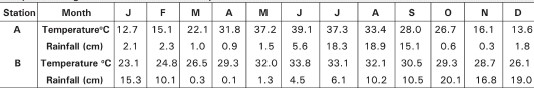
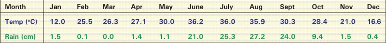
Q-1 Study the data given below of a place in India and answer the questions that follow:
(i) What is annual range of temperature of the place?
(ii) What is the total annual rainfall experienced by this place?
(iii) Is the place located along the coast or inland? Support your answer with a reason.
(iv) For how many months of the year does the place get practically no rain?
(v) How would the trees adapt to cope with the dry summer season?
(vi) What kind of natural vegetation would this place have? Why?
(vii) Name one hardwood tree found in these forests and state its economic importance.
(viii) Name a plant used for making scaffolds.
(ix) Name a plant of this forest used for making handicrafts and also used in perfumery.
(x) On the map given, shade the area that would have the type of vegetation named in (vi).
(ii What is annual range of temperature of the place?
Q-2 Explain briefly:

(i) It is important to grow trees in industrial towns and cities.

(ii) All life would come to an end if there were no trees.
(iii) Forests help conserve fertility of the soil.
(iv) Forests help to control floods.
(v) Forests help to control global warming.
(ii It is important to grow trees in industrial towns and cities.
Q-3 Name the following:

(i) The natural habitat of the Bengal tiger.

(ii) The tidal forest in the delta of the Ganga-Brahmaputra.
(iii) Any one location of a Forest Research Institute in India.
(iv) A type of resin secreted by tiny insects and deposited on trees.
(v) A protest movement started by rural women to stop tree felling.
(ii The natural habitat of the Bengal tiger.
Chapter-7   Water Resources
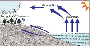
Q-1 Given alongside is a simplified diagram of the hydrological cycle in nature.
(i) State the importance of the hydrological cycle.
(ii) Explain the terms: a. Groundwater b. Surface runoff C. Water table
(iii) Why is groundwater suitable for drinking?
(iv) Name the different types of well that can be used to access groundwater for irrigation.
(v) State the geographical factors that enable well irrigation.
(vi) Why is the lndo-Gangetic-Brahmaputra alluvial plain India's most productive groundwater reservoir.
(vii) What human activities can cause the water table to fall drastically? State the consequences of a low water table.
(viii) What measures can be taken to restore the groundwater?
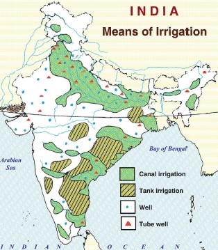
Q-2 The map given alongside shows the distribution of different irrigation systems in India.
(i) What is meant by irrigation?
(ii) Why was it necessary for India to develop its irrigation sector?
(iii) Explain why canal irrigation is practised more in northern India than in peninsular India.
(iv) Account for the greater concentration of well irrigation in North India as compared with South of India.
(v) Tank irrigation is the mode of irrigation practised in the large areas of peninsular India. Explain why.
(vi) What are the drawbacks of surface wells?
(vii) State the disadvantages of tank irrigation.
(viii) India has undertaken major river valley projects. What is a river valley project? Explain the benefits of these projects for a country like India.
(ix) The methods of irrigation shown in the map are conventional means of irrigation. Name three modern methods of irrigation.
(x) State the advantages of these modern methods of irrigation over the conventional methods.
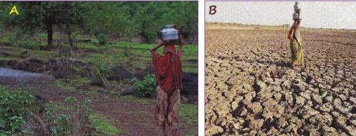
Q-3 Study the pictures A and B pertaining to water scarcity and answer the questions.
(i) What type of water scarcity in indicated in A? What could be the possible cause of this kind of water situation?
(ii) What type of water scarcity in indicated in B? What could be the possible cause of this kind of water scarcity?
(iii) Name a region in India where water scarcity of type B is very common.
Chapter-8   Mineral resources of India
Q-1 On the map given alongside, show the following with appropriate symbols. Give a key for the symbols used.
(i) An area with iron ore deposits in Karnataka.
(ii) An area with the highest reserves of manganese.
(iii) A coastal district in western India which produces bauxite.
(iv) An area with copper deposits in Rajasthan.
(v) An area with the highest iron ore deposits in India.
Q-2 Answer the following questions.
(1) If you wanted to set up an iron and steel factory where would you base it? Give three reasons to support your choice of site.
(2) "The geological processes of mineral formation are so low that the rates of replenishment are very small in comparison to the present rates of consumption". As an individual, in what ways could you contribute towards conserving our mineral wealth?
Chapter-9   Sources of energy - 1 (Conventional)
Q-1 Answer the following questions.
(1) What electric utility delivers electricity to your house?
(2) Why do power stations powered by fossil fuels increase global warming?
(3) If natural gas is so clean, why is it not used in our homes to produce electricity for the household?
(4) In your kitchen, look for a sticker on your appliances that says "Energy Star". What appliances do you see with this sticker? What does it signify?
Q-2 On the map of the Indian subcontinent, show the following with appropriate symbols.
(i) Mark and name two inland oil refineries.
(ii) Two leading states for coal production.
(iii) Two oil refineries that are seaports.
(iv) An offshore site for petroleum.
Q-3 Name:
(i) The four types of coal and give the main uses of each.
(ii) Two raw materials derived from coal.
(iii) The oldest coalfield in India.
(iv) The largest coalfield in India.
(v) The largest refinery in India.
(vi) Three fractions obtained from crude oil and state one use of each.
Chapter-10   Sources of energy - 2 (Non-Conventional)
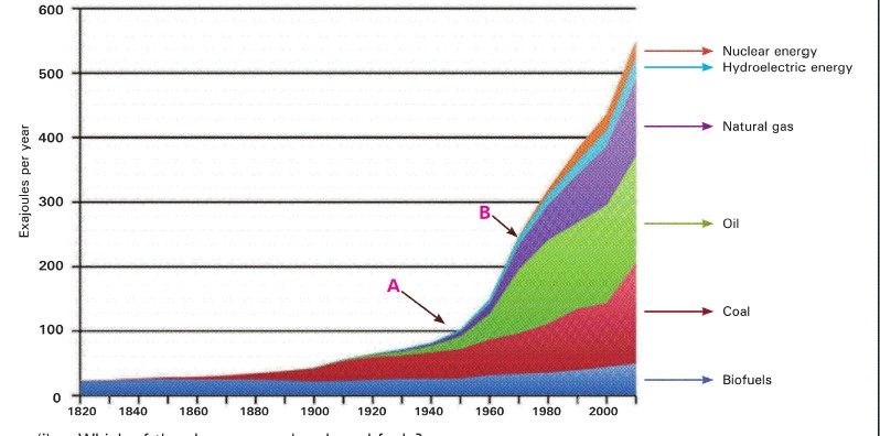
Q-1 Answer the questions based on the graph.
(i) Which of the above are carbon based fuels?
(ii) Name the fuel group that has dominated the energy consumption boom for the last 200 years.
(iii) Which period in history is indicated by the arrow A?
(iv) What is indicated by the steep slope at A? Account for this sudden steepness.
(v) Arrow B shows the introduction of nuclear energy for consumption. When and why was the need felt to explore new energy sources?
(vi) Why is nuclear energy preferred to most of the other fuels?
(vii) Is nuclear energy a renewable energy resource? Explain.
(viii) Mention any two problems associated with the use of nuclear energy.
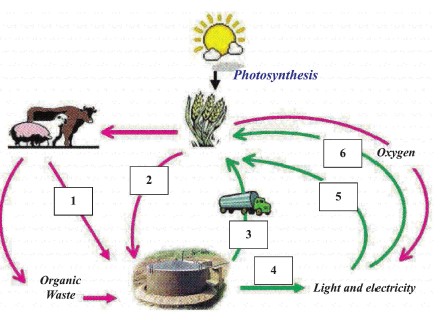
Q-2 Answer the following with respect to the diagram given below.
(i) Label 1 to 6 using the terms given: Water, biogas, vegetable biomass, organic fertiliser, animal manure, carbon dioxide.
(ii) Explain with the help of the diagram how biogas is a sustainable energy source.
(iii) What are the main chemicals present in biogas?
(iv) Name the by-product that is used as a fertiliser.
(v) Why is biogas considered as 'clean technology'?
(vi) State the objectives of the National Project on Biagas Development.
Chapter-11   Agriculture in India
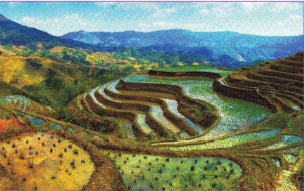
Q-1 The picture shown is of a crop being cultivated on hills slopes . Answer the question based on it.
(i) Rice, tea and coffee are all cultivated on hill slopes. Which of the three is also cultivated in low lying areas?
(ii) Which of the three crops do you think is shown in the picture?
(iii) Give three reasons to support your answer given in (ii).
(iv) State the reasons for eliminating the other two crops.
(v) Describe the cultivation stage shown in the picture.
(vi) What is the source of the water shown in the fields?
(vii) Name a region in India where this type of cultivation is practised and also mention the geographical conditions that favour its cultivation in the named area.
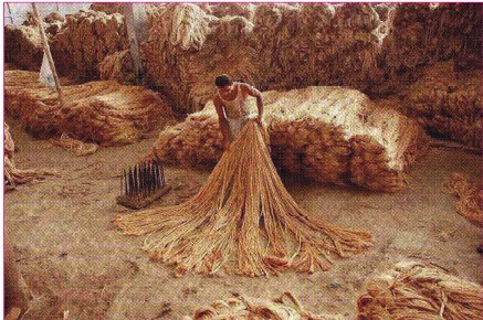
Q-2 The picture shows a stage in the processing of an important cash crop of India.
(i) What is a cash crop?
(ii) This crop is called the "brown paper bag of wholesale trade". Justify this statement.
(iii) Describe the stage that is shown in the picture.
(iv) An important stage preceding this stage is called 'retting'. What is retting? State its significance.
(v) Name another important fibre crop of India and compare both these fibres with respect to the following geographical requirements for their cultivation: a. Temperature b. Rainfall c. Soil
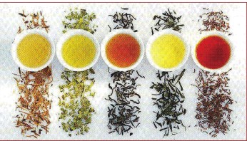
Q-3 The picture shows a variety of tea and tea leaves.
(i) Describe the operation in the processing of tea which changes the natural green colour of the tea leaves into shades of copper.
(ii) Name and briefly describe the operations that precede the above stage in tea processing.
(iii) State the economic importance of the tea industry in India.
Q-4 With reference to the type of soil only, state why:
(i) Jowar is grown in Maharashtra.
(ii) Bajra is grown in Rajasthan.
(iii) Wheat is grown in Western Uttar Pradesh.
Chapter-12   Major Industries of India
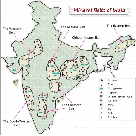
Q-1 The map shows the distribution of minerals in India.
(i) In which mineral belt would you expect to find the most industrialisation? Give reasons to support your answer.
(ii) What are the possibilities of finding iron and steel plants in the Western Belt? Explain why.
(iii) Explain the terms given below and tick all the terms that could apply to the Iron and Steel Industry. * Agro-based Industry * Large scale Industry * Ancillary Industry * Cottage Industry * Heavy Industry * Public Sector Industry * Mineral Based Industry * Key Industry * Consumer Industry * Private Sector Industry
(iv) What are the industries that have developed in the Western Belt? Explain why.
(v) Why is the Petrochemical Industry located along the coast of the Arabian Sea and the Bay of Bengal?
(vi) Mention three geographical factors (other than raw materials) and three non geographical factors that influence the development of industries in certain regions.
Q-2 The Himalayan belt is poor in metallic minerals but the sugar industry has developed in this region.
(i) Why is this region comprising the states of Uttar Pradesh, Bihar, Punjab and Haryana called the 'sugar belt' of India?
(ii) Explain why sugar mills in the cooperative sector have an advantage over those in the private sector.
(iii) India ranks second in the world production of sugar although it is the largest producer of sugarcane. Give reasons.
(iv) In recent years the sugar industry has shown a tendency to migrate towards Southern India. why.
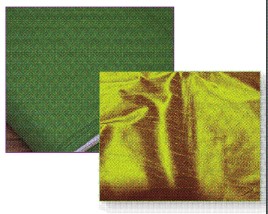
Q-3 Silk and Cotton are two leading textile industries of India.
(i) Account for the concentration of the Cotton Textile Industry in the states of Gujarat, Maharashtra and Tamil Nadu.
(ii) What are the factors that have contributed to Karnataka becoming the leading centre for silk production in India?
(iii) What are the problems being faced by the Cotton Textile Industry?
(iv) State the importance of India's Cotton Textile Industry.
Q-4 Name the cities that form the Silicon Triangle of India and state the reasons that have made these cities leaders of the software industry.
Chapter-13   Transport
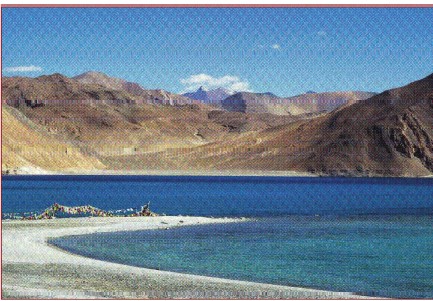
Q-1 This summer vacation your family has decided to take a trip to Leh ladakh . An Atlas would be helpful in planning this holiday.
(i) Find Leh on the map of India and also at what altitude it is located.
(ii) Find out which railway station is closest to Leh.
(iii) What is the distance of the railway station (in kilometres) from Leh?
(iv) Why do you think the train does not go right up to Leh?
(v) What are the possible modes of transport available from the railway station to Leh?
(vi) Is there a commercial airport in Leh?
(vii) Assuming you are travelling from Mumbai to Leh by road. Select a route that goes to Leh via Manali. Name the National Highway(s) and highways you would take to reach Leh.
(viii) On the way you also want to stop by and visit some friends who live in Surat and Vadodara. sure you include these cities while planning the route.
(ix) Would you consider making this trip in winter? Explain your answer.
(x) A major river flows through the Ladakh region. Name the river and explain why it is not suitable as a waterway for inland travel.
(xi) Name the organisation that is responsible for the construction of road in the hilly and mountainous terrain of the Himalayas.
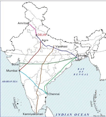
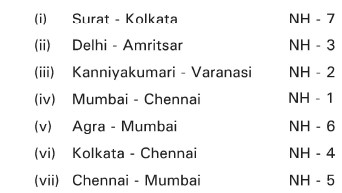
Q-2 Match the National Highway numbers with the corresponding route given on the map. Example: Kanniyakumari - Varanasi NH - 7
Q-3 Explain:
(i) The advantages of using Waterways for transporting goods.
(ii) The eastern coastal strip is served by railways, while the western coastal strip is not.
(iii) Air transport is particularly important in Northeast India?
(iv) The disadvantage of using three different gauges in the railways.
Chapter-14   Waste Management
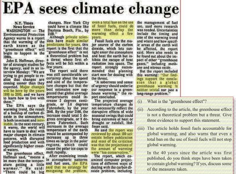
Q-1 The news article given below was published in the 1980s. Read it and then answer the question given.
Q-2 Three types of solid waste are shown below :
(i) Which of these are biodegradable?
(ii) Mention three common methods treating biodegradable waste.
(iii) State the importance or advantages each of the methods mentioned in (ii).
(iv) Which of these should be recycled? Why?
(v) Which of these are hazardous waste?
(vi) Why is incineration or burning not a good option for disposing plastic waste?
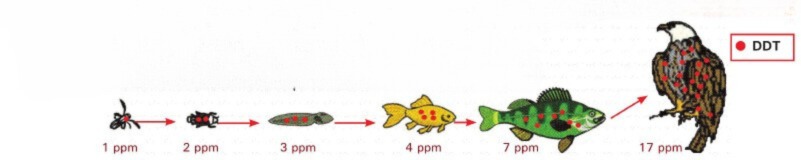
Q-3 DDT is highly toxic to insects. In high concentrations it can cause problems in other animals like shell -thinning and feminisation in birds.
(i) Name and define the process depicted in the illustration below.
(ii) How does DDT enter the ecosystem? How can it be prevented?
Q-4 The following report appeared in June 2015 in the Times of India
(i) What is the impact of the warming Indian Ocean on the monsoon rains in India?
(ii) What is the cause of this warming of the Indian Ocean?
(iii) Why is the monsoon rain critical to the Indian subcontinent?
(iv) Scientists warn that global warming is likely to continue and the situation may become worse. Suggest measures to reduce emission of greenhouse gases.